Thank you for your patience while we retrieve your images.
Taken 6-Jun-10
Visitors 28


145 of 234 photos
Thumbnails
Info
Categories & Keywords

Category:
Subcategory:
Subcategory Detail:
Keywords:flint hill, Cerro Pedernal, Española Ranger District, Its highest point is 9862 feet (3006 meters), Jemez Volcanic Field, NM, Santa Fe National Forest, caprock, chert, flint, high-long butte, lake abiquiu, means "flint hill" in Spanish, mountains, near Abiquiu, north flank of the Jemez Mountains, northern New Mexico, pedernal, prehistoric Gallina people, source of chert, south of Abiquiu Lake, sunset, volcanic, volcanic origins
Photo Info

Dimensions667 x 1000
Original file size870 KB
Image typeJPEG
Color spacesRGB
Date taken6-Jun-10 22:28
Date modified6-Jun-10 22:28
Shooting Conditions

Camera makeCanon
Camera modelCanon EOS 5D Mark II
Focal length17 mm
Exposure1/6 at f/14
FlashNot fired, compulsory mode
Exposure bias+1/3 EV
Exposure modeAuto
Exposure prog.Aperture priority
ISO speedISO 200
Metering modePattern
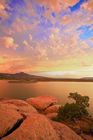
Pedernal, Abiquiu Lake, NM

Pedernal, Abiquiu Lake, NM

The Pedernal & Lake Abiquiu at sunset; Cerro Pedernal, is a high, long butte with volcanic origins. It forms the north flank of the Jemez Mountains, south of Abiquiu Lake, in the Española Ranger District of the Santa Fe National Forest in northern New Mexico. Its name means "flint hill" in Spanish and was the source of chert used by the prehistoric Gallina people. Its caprock was produced in the Jemez Volcanic Field. Its highest point is 9,862 feet (3,006 meters); near Abiquiu, NM